Example: quiz answers
Muir Woods and Vicinity Trail Map - National Park Service
Muir Woods & Vicinity Trail Map The National Park Service preserves the integrity of wild places and our country’s heritage for future generations. As you walk or ride a trail today, alone or with friends, please protect the landscape and its living communities by respecting the trail use guidelines on the map.
Tags:
Information
Domain:
Source:
Link to this page:
Documents from same domain
PLEASE NOTE - National Park Service
www.nps.govTechnical Preservation Services National Park Service 2012 T his booklet describes the Federal Historic Preservation Tax Incentives in general terms only.
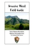
Invasive Weed Field Guide
www.nps.govThis field guide is not intended as a comprehensive reference to all of the weeds in the Santa Monica Mountains National Recreation Area (SMMNRA).
Yosemite, CA 95389 PO Box 577 National Park Service
www.nps.govi The Ansel Adams Gallery Half Dome Village Parking E3 E6 E4 Merc e d Ri v er Lower Yosemite Fall Upper Yosemite Fall Vernal Fall Nevada Fall Bridalveil Fall B r i d a l v e
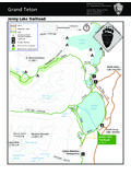
Grand Teton - NPS.gov Homepage (U.S. National …
www.nps.gov8,000 8,000 8,000 10,000 8,000 10,000 10,000 10,000 12,000 JENNY LAKE Lake of the Crags Grand Teton Teton Glacier 13,770 ft Mount Owen 12,928 ft Teewinot Mountain
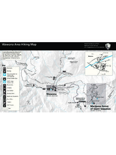
Wawona Area Hiking Map - National Park Service
www.nps.govWawona Area Hiking Map. Yosemite National Park National Park Service. U.S. Department of the Interior. h. hilnualna Falls, ft , m Wawona eadow, ft , m
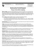
Backcountry Permit Request - National Park Service
www.nps.govNOTICES . Notice Regarding the Use of Cell/Satellite Phones and Personal Locator Beacons. Communication devices may be helpful, but do not guarantee your …
ARCHES NATIONAL PARK
www.nps.govNorth 0 0 1 1 2 2 3 3 4 Miles 4 Kilometers 191 191 279 128 128 313 70 191 313 313 313 70 191 128 191 128 191 191 C O L O R A D O S KC Visitor Center R …
BRYCE CANYON NATIONAL PARK - NPS.gov …
www.nps.gov087 12 63 89 No trailers beyond this point Road closed from here to Rainbow Point during winter storms BRYCE CANYON NATIONAL PARK Riggs Spring Iron Spring
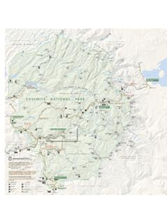
YOSEMITE NATIONAL PARK
www.nps.gov120 167 120 140 41 395 Fish Camp Lee Vining Yosemite West Chinquapin El Portal Foresta Mather To Fresno To Merced To Manteca To Carson City, Nev. To …
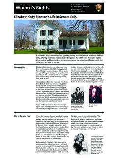
National Park Service Women’s Rights U.S. …
www.nps.govGrowing Up Life in Seneca Falls Elizabeth Cady was born in Johnstown, New York on November 12, 1815, the daughter of Daniel Cady, a lawyer, a judge, and land specu-
Related documents
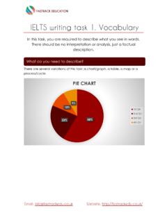
IELTS writing task 1. Vocabulary
edisciplinas.usp.brVicinity Remote Considerable distance Walking distance North South East West North east South east North west South west Passes through Crosses Runs along Connect Link to Was established Was built Was replaced by Rural Industrial Main road Population Railway Residential area City centre Town Coast ...
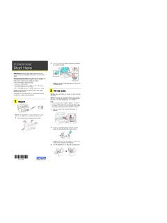
102 Lift up the scanner unit. Remove all protective ...
files.support.epson.com• Do not use a telephone to report a gas leak in the vicinity of the leak. Caution: To reduce the risk of fire, use only a No. 26 AWG or larger telecommunication line cord. The illustrations show the ET-4760, but the steps are the same for all models, unless otherwise specified. 1 Unpack

Preface - Federal Aviation Administration
www.faa.govJan 01, 2005 · transponders of all aircraft in the vicinity and based on the replies received, tracks the slant range, altitude (when it is included in the reply message), and relative bearing of surrounding traffic. From several successive replies, TCAS calculates a time to reach the CPA (Closest Point of Approach) with the intruder, by dividing the range by the
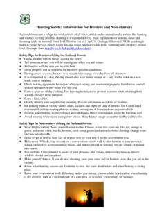
Hunting Safety: Information for Hunters and Non-Hunters
www.fs.usda.govvicinity. • Know when hunting seasons are. Continue to hike, but learn about where and when hunting is taking place. • Know your own comfort level. If hunting makes you uneasy, choose a hike in a location where hunting is not allowed, such as a national park or a state park, or schedule your outings for Sundays.

Player Development Initiatives
www.usyouthsoccer.org•Goal kicks and corner kicks should be taken in the general vicinity of the respective goal or corner •If used, all free kicks are indirect •Opponents should be 10 feet away from the ball on all restarts •No penalty kicks •No offside 22
COLREGS - International Regulations for Preventing ...
www.mar.ist.utl.ptLloyd’s Register Rulefinder 2005 – Version 9.4 COLREGS - International Regulations for Preventing Collisions at Se a - Articles of the Convention on the
Interim Guidance on the Length of Quarantine for Contacts ...
portal.ct.govDec 16, 2020 · Phone: (860) 509-7995 • Fax: (860) 509-7910 Telecommunications Relay Service 7-1-1 410 Capitol Avenue, P.O. Box 340308 Hartford, Connecticut 06134-0308