Transcription of REMOTE SENSING FROM SPACE - Princeton …
1 Chapter 7 REMOTE SENSING FROM SPACEC ontentsPageIntroduction ..253 The Systems ..253 REMOTE SENSING Policy ..254 Applications of Remotely Sensed Data ..,.257 Meteorological REMOTE SENSING Systems .. Systems .. 258 Possible Future Directions .. 258 Foreign Systems.., , ..260 International Cooperation in MeteorologicalSatellite Systems ..264 Data Products and Service ..266 Market for Metsat Equipment and Services..270 Meteorological Satellite Issues ..273 Land REMOTE SENSING Systems..278 The Landsat System ..278 System Development ..280 Foreign Landsat Receiving Stations ..280 Data Products and Uses ..285 Policy History of Land REMOTE SENSING ..286 International Relevance of Landsat ..291 Equipment Market ..292 Issues .., .. , ..293ocean REMOTE SENSING .. Oceanographic Systems ..303 Foreign Systems..305 Major Ocean Parameters of lnterest forScientific and Applied Uses..307 Applications of Ocean REMOTE SENSING .
2 310 Issues in Ocean REMOTE SENSING .. 312 REMOTE SENSING Policy ..314 Meteorological REMOTE SENSING Policy ..315 Land REMOTE SENSING Policy ..319 Options for Continued Financial Support .,.319 Additional Policy Options. , ..321 Cooperation .. 322 Ocean REMOTE SENSING Policy .. 323 Appendix 7A. Satellite REMOTE SENSING inDeveloping Countries ..325 The Experience of Developing Countries . 325 Institutional Factors Influencing the Use ofSatellite REMOTE SENSING .. 328 Political Constraints.. 329 Appendix 7B. Environmental Satellites,1960-85 .. 332 List of TablesTab/e , Countries With APT/HRPT ReceptionCapabilities.. 2677-2. Domestic Users of MeteorologicalSatellite Data .. 2697-3. Derived Meteorological SatelliteProducts .. 2697-4. National Weather Service Hurricane,International Aviation, and MarineForecast Programs .. 2697-5. Costs for Some Landsat Data Products.
3 , ,7-14,7-15, Imaging Sensors UnderDevelopment by NASA , .. 282 Foreign Landsat Ground Stations .. 284 Categories of Foreign and DomesticUsers .. 285 Domestic Distribution of LandsatProducts .. 286 Customer Profile of Landsat Total Data .297 Agribusiness Industry Structure Analysis 300 Geophysical OceanographicMeasurement Design Capabilitiesfor Seasat-A .. 302 Measurement Needs for OceanographicSatellites .. 305N-ROSS Sensor Capabilities .. 306 Oceanographic Data TacticalOperations .. 307 Ice Parameters of lmportance inDifferent Operations and ResearchAreas .. 309 Possible Oceanographic SatelliteApplications .. 311 Impacts of Observed Parameters onCommercial Benefits .. 311 Agency for International DevelopmentRemote SENSING Grants and Projects,1971-85 .. , , , , of Earth, Received Aug. 8, 1980,by GOES Satellite.. 255image of Northeast United States Takenin February 1979 by the NOAA-N SeriesPolar-Orbiting Satellite.
4 256 Image of New York City and EnvironsTaken by the Thematic Mapper .. 257 Advanced TIROS-N .. 262 GOES Satellite .. 263 GOES Geographic Coverage .. 264 Path of Geosynchronous Satellite inInclined .. 265 Operational Earth Observation Satellites 268 One-and Two-Polar Soundings .. 276 Landsat-5 Spacecraft .. 279 Cutaway View of the MultispectralScanning System .. 280 Landsat Bands and Electrc)magneticSpectrum Comparison .. 281 Thematic Mapper Sensor .. 281 Distribution by Foreign Ground Stations 283 Customer Profile of Landsat Digital andImagery Products, Fiscal Year 1984 .. 287 Sale of Landsat Imagery Framesand Digital Products .. 296 The Seasat-A Spacecraft .. 303 Navy REMOTE Ocean SENSING Satellite .. 306 Radar lmage of Kuskokwim Bay inAlaska .. 309 List of FiguresFigure Polar-Orbiting and GeostationarySatellites .. 254 Chapter 7 REMOTE SENSING FROM SPACEINTRODUCTIONThe value of viewing Earth from SPACE to pro-vide crucial resource and environmental infor-mation on the atmosphere, oceans, and landmasses was recognized early in this Nation s de-velopment of SPACE technology.
5 It was an obviousextension of REMOTE SENSING by aircraft and bal-loons, technologies that were already Two years after the National Aeronauticsand SPACE Act was signed, the United States re-ceived its first images from SPACE taken by thepolar-orbiting2 weather satellite called the Televi-sion and infrared Observation Satellite (TIROS).This chapter describes the principal remotesensing systems that have been developed by theUnited States and other countries and those thatare now under development. It draws heavily ona technical memorandum published in 1984 inconnection with this assessments The chapter ex-plores the primary issues connected with the gen-eration, distribution, and application of remotelysensed data, and assesses various policy optionsfor Congress to consider as it debates the needfor REMOTE - SENSING technology for the atmos-phere, land, and I n general terms, REMOTE SENSING is the art of obtaining informa-tion about objects, areas or phenomena through analyzing datagathered by devices placed at a distance from the subjects of SENSING may refer to SENSING over short distances, as in med-ical or laboratory research applications using lasers, or over longdistances as in environmental monitoring from satellite platformsusing advanced electro-optical instruments.
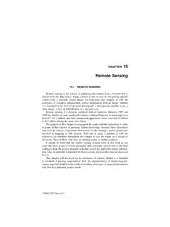
6 Once the initial dataare sensed, they must be analyzed and interpreted either visuallyor through sophisticated computer n a polar orbit the satellite is inclined nearly 90 degrees to theEquator. As the satellite orbits, the Earth turns beneath, making pos-sible direct overhead observations of the entire Earth over a givenperiod. The geostationary satellites, by contrast, provide continu-ous viewing but are limited to providing perpendicular viewing atonly one longitude at the equator. All other points on Earth aresensed at some angle. They therefore see the polar regions ata highly oblique angle. The orbital elements of the meteorologicalTIROS satellit~ are so chosen to allow them to pass over everyportion of Earth s surface twice every 24 hours, once passing fromnorth to south, and once passing from south to north. REMOTE SENSING and the Private Issues for Discussion(Washington, DC: Congress, Office of Technology Assessment,OTA-TM-ISC-20, March 1984).
7 The SystemsThe National Oceanic and Atmospheric Ad-ministration (NOAA)4 operates two civilian sys-tems (fig. 7-1 ) for making global meteorologicalobservations: a geostationary system (Geosta-tionary Orbiting Environmental Satellite GOES)using two satellites that continuously monitorweather systems within their field of view (fig. 7-2);5 and a polar-orbiting meteorological system(Advanced Television and Infrared ObservationSatellite TIROS) that observes meteorologicalphenomena in more detail over the entire globefrom two satellites (fig. 7-3).NOAA also operates the polar-orbiting system, which was developed by theNational Aeronautics and SPACE Administration(NASA), to provide valuable data of high spatialand spectral resolution (fig. 7-4) of Earth s landresources. Data from the system support a vari-ety of applications, including assessing and man-aging renewable and nonrenewable resources,mapping, and land-use planning.
8 The Landsat sys-tem was transferred to NOAA in 1983 and is nowmanaged as an operational system. The Depart-ment of Commerce is currently attempting totransfer the Landsat system to private REMOTE SENSING systems are the least de-veloped of REMOTE SENSING efforts. Although theresults from such experimental ocean satellitesas Seasat, Nimbus, and the Geodynamic Experi-4 The development of the weather satellite began in the DOD,but was transferred to NASA in 1959. In 1961 the Weather Bureauwas placed in charge of providing an operational weather satellitesystem. Operational satellite services were moved to the Environ-mental Science Services Administration in 1965 and finally to NOAAin 1970. They now reside in the National Environmental SatelliteData and Information Service (N ESDIS), which is part of juIy 30, 1 g84, GOES-5 failed in orbit. This left the UnitedStates with only a single geostationary satellite (the western satel-lite, GOES-6) to provide data during the critical severe storm seasonsof the summer and early fall.
9 To make up (in part) for the !OSS ofinformation that losing the eastern satellite entailed, NOAA movedGOES-6 to a central location. This meant reduced weather servicefor Alaska, Hawaii, and the Pacific Trust Territories. GOES-7, thereplacement for the failed GOES-5, will not be available for launchuntil late in 1985 or early 254 l International Cooperation and Competition in Civilian SPACE ActivitiesFigure 7-1. Polar-Orbiting and Geostationary SatellitesPolar orbiting satellitesNGilmore Creek,Alaska530 miearth rotationOrbit path E&per orbitsOrbit planerotates eastward1 per daySOURCE: National Oceanic and Atmospheric ,VirginiaGeostationary satellitesmental Ocean Satellite have created interest indeveloping REMOTE SENSING systems that will pro-vide resource information from the oceans, nocivilian operational system is SENSING from SPACE at present consti-tutes a small part of a larger array of mappingservices provided by terrestrial and airborne The data acquired from SPACE are nowroutinely integrated with other remotely senseddata (aircraft and balloons) and terrestrial, air, andwater measurements, thus enhancing the value,and expanding the application of both data discussed in detail below, other countries ei-ther operate, or have under development, vari-ous REMOTE SENSING systems.
10 A few efforts, others will compete with u .S. Navy is planning a system called Navy REMOTE OceanSensing System (N-ROSS) which may be launched in 1988 or data from this system will be available to civilian users throughNOAA (see section on Ocean REMOTE SENSING ).Zln fisca[ year 1984, sales of Lan4sat data made up 34 percentof the total sales of remotely sensed data from the EROS Data Centerin Sioux Falls, SD. Private services also sense and sell aircraft SENSING PolicyAlthough the United States has led the worldin the development and operation of civilian re-mote SENSING systems, this year it will face com-petition from France for the sale of land remotesensing data products. There is little commercialmarket for data sales from meteorological sys-tems, but opportunities do exist for broad multi-national cooperation in providing meteorologicaldata from SPACE . The United States is exploringthe prospect of joining with other Free Worldspace-capable nations in building a cooperativepolar-orbiting global meteorological satellite sys-tem.]