
Professional Edition, Version 1 - Agisoft PhotoScan
v Overview Agisoft PhotoScan is an advanced image-based 3D modeling solution aimed at creating professional quality 3D content from still images.
Download Professional Edition, Version 1 - Agisoft PhotoScan
Information
Domain:
Source:
Link to this page:
Documents from same domain
Tutorial (Beginner level): 3D Model Reconstruction …
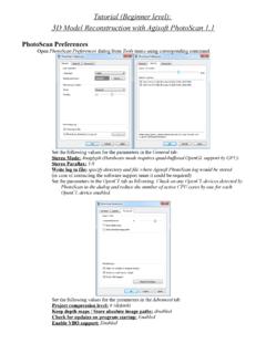
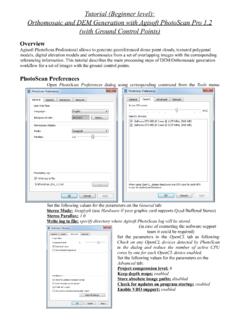
www.agisoft.comTutorial (Beginner level): 3D Model Reconstruction with Agisoft PhotoScan 1.1 PhotoScan Preferences Open PhotoScan Preferences dialog from …
Tutorial (Intermediate level): Volume …
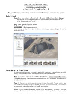
www.agisoft.comTutorial (Intermediate level): Volume Measurements with Agisoft PhotoScan Pro 1.1 This tutorial illustrates how to perform volume measurements for …
Agisoft PhotoScan Change Log
www.agisoft.com1 Agisoft PhotoScan Change Log Version 1.4.3 build 6529 (21 July 2018) Standard and Professional editions • Added Generate Report command to Standard edition.

Professional Edition, Version 1 - Agisoft PhotoScan
www.agisoft.comv Overview Agisoft PhotoScan is an advanced image-based 3D modeling solution aimed at creating professional quality 3D content from still images.
Tutorial (Beginner level): Orthomosaic and DEM …
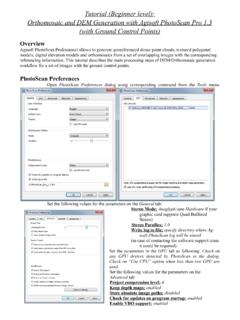
www.agisoft.comTutorial (Beginner level): Orthomosaic and DEM Generation with Agisoft PhotoScan Pro 1.3 (with Ground Control Points) Overview Agisoft PhotoScan Professional allows to generate georeferenced dense point clouds, textured polygonal

Professional Edition, Version 1 - PhotoScan
www.agisoft.com1 Chapter 1. Installation and Activation System requirements Minimal configuration • Windows XP or later (32 or 64 bit), Mac OS X Mountain Lion or …
Tutorial (Beginner level): Orthomosaic and DEM Generation ...
www.agisoft.comOrthomosaic and DEM Generation with Agisoft PhotoScan Pro 1.2 (with Ground Control Points) Overview Agisoft PhotoScan Professional allows to generate georeferenced dense point clouds, textured polygonal models, digital elevation models and orthomosaics from a set of overlapping images with the corresponding referencing information.
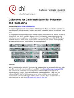
Guidelines for Calibrated Scale Bar Placement and Processing
www.agisoft.comGuidelines for Calibrated Scale Bar Placement and Processing Authored by Cultural Heritage Imaging To support highly accurate measurement of 3D data of …

Professional Edition, Version 1 - Metashape
www.agisoft.com• Windows 7 SP 1 or later (64 bit), Windows Server 2008 R2 or later (64 bit), macOS Mojave or later, Debian/Ubuntu with GLIBC 2.19+ (64 bit) • Intel Core i7 or AMD Ryzen 7 processor • Discrete NVIDIA or AMD GPU (4+ GB VRAM) • 32 GB of RAM The number of photos that can be processed by Metashape depends on the available RAM and

Professional Edition, Version 1 - Metashape
www.agisoft.comcapability 2.0 and higher or OpenCL 1.1 and higher enabled device with SPIR support for stages specified above, provided that CUDA/OpenCL drivers for the device are properly installed. However, because of the large number of various combinations of video chips, driver versions and operating systems, Agisoft
Related documents
Agisoft PhotoScan Change Log
www.agisoft.com1 Agisoft PhotoScan Change Log Version 1.4.3 build 6529 (21 July 2018) Standard and Professional editions • Added Generate Report command to Standard edition.

測量への無人航空機(UAV)の 導入に向けた検討 …
www.gsi.go.jpMGeinoissptrayt ioafl ILnafnodr,m Inaftriaosnt rAuuctthuorer,i tTyr oafn sJpaopratn and Tourism 測量への無人航空機(UAV)の

測量機器検定基準 - kago-kengi.or.jp
www.kago-kengi.or.jp河川測量精度管理表 距離標設置測量精度管理表・・・中心線測量に準じる 水準基標測量精度管理表・・・・水準測量に準じる
Evaluation of UAV Photogrammetric Accuracy for …
www.underhill.caG E O M A T I C A EVALUATION OF UAV PHOTOGRAMMETRIC ACCURACY FOR MAPPING AND EARTHWORKS COMPUTATIONS Chris Cryderman, S. Bill Mah, Aaron Shufletoski Underhill Geomatics Ltd., Canada