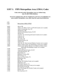
Transcription of Chapter 11 Census Blocks and Block Groups
1 Census Blocks , the smallest geographic area for which the Bureau of the Census collects and tabulates decennial Census data, are formed by streets, roads, railroads, streams and other bodies of water, other visible physical and cultural features, and the legal boundaries shown on Census Bureau maps. Census data for these areas serve as a valu-able source for small-area geographic studies. The Census Bureau hasresponded to public demand for more geographic coverage of Census Block data by expanding the Census Block Statistics Program each dec- ade since Block data first were published in 1940.
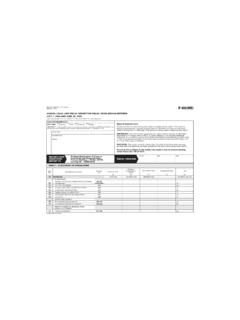
2 For the 1990 decen-nial Census , the Census Bureau tabulated data by Census Block for the entire Nation, as well as Puerto Rico and the Outlying Areas (Ameri-can Samoa, Guam, the Northern Mariana Islands, Palau, and the Virgin Islands of the United States). In 1990, the Census Bureau tabulated data for 7,020,924 Census Blocks . Block Groups (BGs) are the next level above Census Blocks in the geo-graphic hierarchy (see Figure 2-1 in Chapter 2). A BG is a combination of Census Blocks that is a subdivision of a Census tract or Block number-ing area (BNA).
3 (A county or its statistically equivalent entity contains either Census tracts or BNAs; it can not contain both.) A BG consists of all Census Blocks whose numbers begin with the same digit in a given Census tract or BNA; for example, BG 3 includes all Census Blocks num-bered in the 300s. The BG is the smallest geographic entity for which the decennial Census tabulates and publishes sample data. It has now largely replaced the earlier enumeration district (ED) as a small-areageographic unit for purposes of data presentation.
4 For the 1990 decennial Census , local Census statistical areas committees were given the opportunity to delineate BGs in counties with Census tracts. State officials were invited to delineate BGs in the remaining coun-ties. The Census Bureau delineated BGs for counties in which local and State officials chose not to participate in the BG program. The total num-ber of BGs delineated for the 1990 decennial Census was 229,466. Census Blocks and Block Groups 11-1 Census Blocks and Block GroupsChapter 1111-2 Census Blocks and Block GroupsHistory of Small Areas in CensusesThroughout most of the 1800s, the smallest data unit for which the CensusBureau collected information was the area assigned to an individual enu-merator, and the smallest area for which it reported data corresponded togeographic entities such as wards, communities, and townships.
5 Historiesof the early censuses contain very little precise information abouthow these entities were subdivided for enumeration. Many of the assign-ments were verbal descriptions based on legally defined entities, commu-nity names, and major physical features. Some enumerators developedtheir own geographic solutions by drafting sketch maps and by writingdescriptions of their enumeration area of Enumeration Districts From 1870 Through 1980 Over time, the instructions for enumerators became more specific; theyrevealed an increasing concern for the boundaries, size, and identificationof geographic subdivisions.
6 For the 1870 Census , the Census Office (pred-ecessor of the Census Bureau) lowered the maximum size of the subdis-tricts used for enumeration from 50,000 to 6,000 people. For the 1880census, this number was reduced to 4,000, resulting in approximately28,000 districts of enumeration (later called enumeration districts, or EDs).This Census also was the first in which the Census Office provided mapsof EDs for use in taking the 1910, the Census Bureau began to delineate EDs to follow the bound-aries of legally or administratively defined entities such as villages, cities,wards, and minor civil divisions (MCDs).
7 This approach permitted theconvenient aggregation of EDs into larger geographic entities for tabula-tion and publication. It also underlined the need for maps to show theboundaries of counties, incorporated places, and MCDs in their correctlocation. The Census Bureau began to improve the ED maps, and for the1930 Census , included ED boundaries and numbers on all maps used inthe field ED, with minor revisions and improvements, continued to be thesmallest geographic unit for which Census data were available until censusCensus Blocks and Block Groups 11-3blocks were introduced for larger places in the 1940 Census .
8 Even then,because Blocks were numbered only in limited areas, EDs continued tobe used as a collection and reporting unit in decennial censuses throughthe 1980 Blocks as Collection, Tabulation, and Publication UnitsLike the ED, the Census Block originally served the operational needs ofthe Census Bureau. As early as the 1920 Census , the Census Bureau wasinstructing its enumerators in cities and built-up areas to do their workblock by Block : .. canvass one Block or square at a time .. Do not go back and forth acrossthe street.
9 Be sure you have gone around and through the entire Block beforeyou leave it. The Census Bureau found that following a Block -by- Block sequence wasan efficient way to compile data summaries at the ED level, and it graduallyextended this enumeration method to rural areas as well as urban. Canvass-ing individual Blocks in a geographic sequence remains the Census Bureau sstandard method of listing and verifying addresses or conducting a tradi-tional door-to-door enumeration (see Figure 11-1).Demographers, statisticians, and other data users had wanted to obtaincensus data by Block long before the Census Bureau was able to undertakesuch detailed geographic subdivision.
10 For instance, in 1909, the TenementHouse Department of New York city had wanted the Census Bureau toidentify more than 49,000 city Blocks as part of the data dissemination forthe 1910 Census . Expression of such needs undoubtedly influenced theCensus Bureau s eventual decision to compile and present information atthe Block Census Bureau first published Census Block data in 1940 as part of thenewly created Census of Housing. These Block statistics provided a detailedinventory of housing conditions within major cities during an era of Federalfinancial support for public works projects.