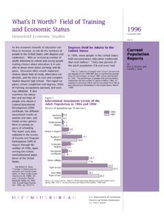
Transcription of Definitions and Explanations - Census.gov
1 1 Definitions and Explanations The United States Office of Management and Budget (OMB) defines metropolitan and micropolitan statistical areas according to published standards that are applied to census Bureau data. The general concept of a metropolitan or micropolitan statistical area is that of a core area containing a substantial population nucleus, together with adjacent communities having a high degree of economic and social integration with that core. Standard Definitions of metropolitan areas were first issued in 1949 by the then Bureau of the Budget (predecessor of OMB), under the designation "standard metropolitan area" (SMA).
2 The term was changed to "standard metropolitan statistical area" (SMSA) in 1959, and to "metropolitan statistical area" (MSA) in 1983. The term "metropolitan area" (MA) was adopted in 1990 and referred collectively to metropolitan statistical areas (MSAs), consolidated metropolitan statistical areas (CMSAs), and primary metropolitan statistical areas (PMSAs). The term "core based statistical area" (CBSA) became effective in 2000 and refers collectively to metropolitan and micropolitan statistical areas.
3 OMB has been responsible for the official metropolitan areas since they were first defined, except for the period 1977 to 1981, when they were the responsibility of the Office of Federal Statistical Policy and Standards, Department of Commerce. The standards for defining metropolitan areas were modified in 1958, 1971, 1975, 1980, 1990, 2000, and 2010. Beginning in first quarter 2015, the Current population Survey/Housing Vacancy Survey began using the new metropolitan and micropolitan statistical Definitions announced by OMB in February 2013, and were based on the application of the 2010 standards to census 2010 data.
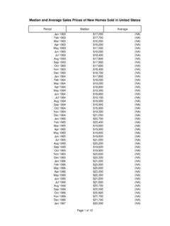
4 The February 2013 Definitions are available at: The 2015 metropolitan area data reflect 2010 Definitions , the 2005 to 2014 data reflect 2000 Definitions , the 1995 to 2004 data reflect 2000 Definitions , and the 1986 to 1994 data reflect 1990 Definitions . Therefore, metropolitan/nonmetropolitan data prior to 1986, 1986 to 1994, 1995 to 2004, 2005 to 2014 and 2015 and later are not directly comparable to each other. Defining Metropolitan and Micropolitan Statistical Areas. The term Core Based Statistical Area (CBSA) is a collective term for both metro and micro areas.
5 The 2010 standards provide that each CBSA must contain at least one urban area of 10,000 or more population . Each metropolitan statistical area must have at least one urbanized area of 50,000 or more inhabitants. Each micropolitan statistical area must have at least one urban cluster of at least 10,000 but less than 50,000 population . Under the standards, the county (or counties) in which at least 50 percent of the population resides within urban areas of 10,000 or more population , or that contain at least 5,000 people residing within a single urban area of 10,000 or more population , is identified as a "central county" (counties).
6 Additional "outlying counties" are included in the CBSA if they meet specified requirements of commuting to or from the central counties. Counties or equivalent 2 entities form the geographic "building blocks" for metropolitan and micropolitan statistical areas throughout the United States and Puerto Rico. If specified criteria are met, a metropolitan statistical area containing a single core with a population of million or more may be subdivided to form smaller groupings of counties referred to as "metropolitan divisions.
7 " As of February 2013, there are 381 metropolitan statistical areas and 536 micropolitan statistical areas in the United States. Principal cities and Metropolitan and Micropolitan Statistical Area. The largest city in each metropolitan or micropolitan statistical area is designated a "principal city." Additional cities qualify if specified requirements are met concerning population size and employment. The title of each metropolitan or micropolitan statistical area consists of the names of up to three of its principal cities and the name of each state into which the metropolitan or micropolitan statistical area extends.
8 Titles of metropolitan divisions also typically are based on principal city names but in certain cases consist of county names. Defining New England City and Town Areas. In view of the importance of cities and town in New England, the 2010 standards also provide for a set of geographic areas that are delineated using cities and towns in the six New England states. The New England city and town areas (NECTAs) are delineated using the same criteria as metropolitan and micropolitan statistical areas and are identified as either metropolitan or micropolitan, based, respectively, on the presence of either an urbanized area of 50,000 or more population or an urban cluster of at least 10,000 but less than 50,000 population .
9 If the specified criteria are met, a NECTA containing a single core with a population of at least million may be subdivided to form smaller groupings of cities and towns referred to as New England city and town area divisions. Changes in Definitions over Time. Changes in the delineations of these statistical areas since the 1950 census have consisted chiefly of the recognition of new areas as they reached the minimum required city or urbanized area population , and the addition of counties (or cities and towns in New England) to existing areas as new decennial census data showed them to qualify.
10 In some instances, formerly separate areas have been merged, components of an area have been transferred from one area to another, or components have been dropped from an area. The large majority of changes have taken place on the basis of decennial census data. However, census Bureau data serve as the basis for intercensal updates in specified circumstances. Geographic regions. The four major regions of the United States for which data are presented in this report represent groups of States as follows: Northeast: Connecticut, Maine, Massachusetts, New Hampshire, Rhode Island, Vermont, New Jersey, New York, Pennsylvania.