Transcription of Geographic Information Systems (GIS) - Advanced …
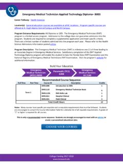
1 College Catalog 2017-2018 Geographic Information Systems (GIS)- Advanced technical certificate (4277) Career Pathway: Science, Technology, Engineering, and Math (STEM) Location(s): General Education courses can be taken at any college location. Program specific courses may only be offered at Central Campus. Please consult the course schedule semester for locations. Program Entrance Requirements: Students must hold a minimum of an Associate s degree. Program Description: This certificate program prepares student for employment as a Geographic Information Systems (GIS) technician or provides GIS training to those currently employed in these occupations.
2 The curriculum includes basic computer skill classes, use of spatial databases for the storage of Geographic data, creation of maps and analysis of spatial Information , and related technologies of remote sensing and global posistioning system (GPS) and how they integrate with GIS. The classes provide extensive training with the popular ArcGIS software. Visit the program s website for more Information . Build Your Education Recommended Course Sequence for Graduates Full Time Part Time Course ID Description Credits Term 1 Term 1 GIS1040C Introduction to GIS I 3 GIS1042C Introduction to GIS II 3 Term 2 GIS1030 Remote Sensing Applications 3 GIS1047C Applications for GIS Systems 3 Total Program Credit Hours 12 This is only a recommended course sequence.
3 Students are strongly encouraged to meet with an advisor to create a personalized educational plan. Environmental Science Technology AS 2182 Geographic Inforamation system ATD 4277 Bachelor of Science College Catalog 2017-2018 Program Highlights Credit for Prior Learning: Accelerate your path to completion with these options: Credit by exam Earned Industry certifications Prior Learning Assessment And much Related Industry Certifications: Upon completing this program, graduates will be eligible to sit for the following industry certifications/licenses: N/A Get Career Ready: After completing your first year of coursework make sure to visit the Career Center for internship opportunities that help you take your career to the next level!
4 Also, explore hundreds of career videos and career profiles through Virtual Job Shadow! Get an Internship Virtual Job Shadow Tool Median Wage and Job Growth Outlook: broward College has Career Coach & the Career Ladders. These tools are designed to help you find a good career by providing the most current local data on wages, employment, job postings, and associated education and training. Learn how to climb your career ladder. Fund Your Education: This Program is Financial Aid eligible. Scholarships may be available.